
Muriwai Coastal Geographic Environment
N.C.E.A. Assessment Specifications
Demonstrate comprehensive understanding of how interacting natural processes shape a New Zealand geographic environment involves:
- providing an insightful analysis of the interacting natural processes and how they shape the environment
- integrating comprehensive supporting case study evidence.
Basic Information
Muriwai Coastal Geographic Environment (M.C.G.E.) is located approximately 41 km north west of Auckland City off State Highway 16.
It is a regionally important area and receives over a million visitors per year.
A range of important geographic features can be found in the area produced by the interacting processes of coastal erosion, transportation and deposition.
These main features are :-
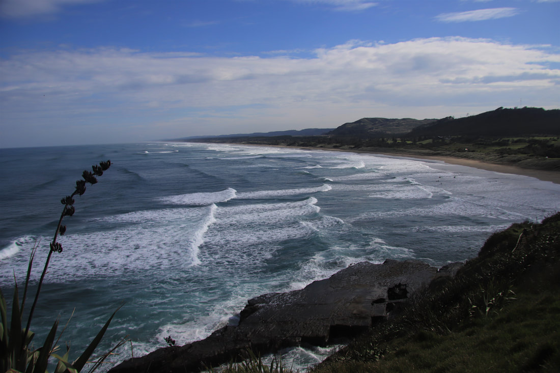
The Beach made up of titanomagnetite sand deposited by longshore currents travelling north. This sediment comes mainly from the Tongariro and Taranaki Areas and are deposited out to sea by the Waikato River where longshore currents sweep the sediment in a northerly direction. The beach is a large sandspit running 56km N.W. to the mouth of the Kaipara Harbour. At Elim Christian College we study only the Southern Beach area running some 2.5 km from the stack (Motutara Island) to Okiritoto Stream.
The Beach has a shallow angle and is prone to erosion. During storms and high tides the sea has been known to sweep all the way inland to the dunes eroding them into a “cliffed formation”. Many holes are formed in the beach causing rips to form. An offshore bar is also present which moves depending on the season and sea conditions. Most of the eroded material is moved northwards by longshore drift and currents or in an easterly direction by aeolian processes.
The Dunes are part of a Coastal Hazard Zone established by the then Auckland Regional Council about 30 years ago. They are fenced off to the south and human activity is limited.
They have been fixed somewhat with vegetation such as marram grass, spinifex and pingao, however in the southern area they are exceptionally fragile and prone to blowouts. The need to protect the areas directly behind the dunes (consisting of
Golf Course, car parks, Surf Life Saving Club, Caravan Park etc.) has led to a variety of methods to stabilise the dunes. Currently it is felt that fixing smaller, lower dunes with vegetation is the best option.
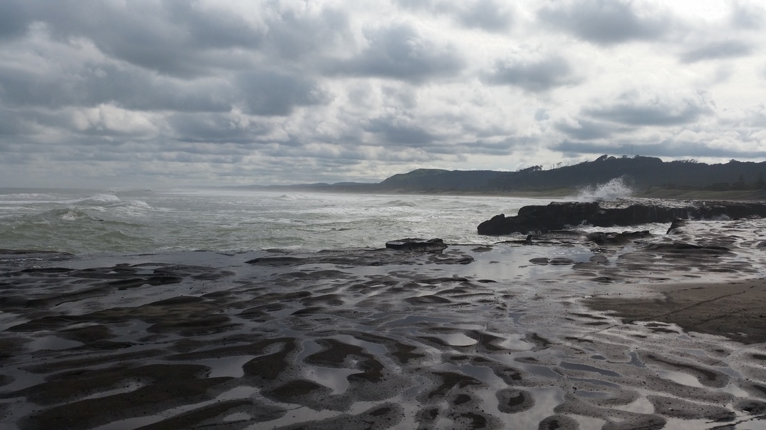
Otakamiro Point and the Cliff Area is made up of a mixture of different rocks. Some are simple limestone and therefore prone to chemical weathering while others are sedimentary sandstones mixed with igneous. Muriwai is also part of the Waitakere Ranges wehich are eroded remains of an old volcanic system that oncew extended the length of Northland. 20 million years ago they were the scene of many major eruptions between the Manukau and the Hokianga Harbours. When the Pacific Plate moved beneath the Australian Plate a chain of eruptions, mainly on the seabed, gave rise to the volcanic rocks of the Waitakeres. The andesites and basalts of the Waitakeres were erupting on the sea floor while the Waitemata sandstone beds were being deposited. As sea levels dropped the Waitakeres were exposed to the air and therefore erosional processes. Much of the volcanic andesites and basalts have been mixed with the sedimentary sandstones to form a Breccia or mixture. The two shore platforms, Flat Rock and Otakimiro Point are made up of limestone and chemical weathering has eroded holes into the top while hydraulic action abrasion and attrition has eroded at the interface of platform and sea. The cliffs are sedimentary rock with smaller volcanic rocks and stones embedded in them. They have mainly been eroded back from the platforms by vertical erosion and mechanical weathering.
It is a regionally important area and receives over a million visitors per year.
A range of important geographic features can be found in the area produced by the interacting processes of coastal erosion, transportation and deposition.
These main features are :-
The Beach made up of titanomagnetite sand deposited by longshore currents travelling north. This sediment comes mainly from the Tongariro and Taranaki Areas and are deposited out to sea by the Waikato River where longshore currents sweep the sediment in a northerly direction. The beach is a large sandspit running 56km N.W. to the mouth of the Kaipara Harbour. At Elim Christian College we study only the Southern Beach area running some 2.5 km from the stack (Motutara Island) to Okiritoto Stream.
The Beach has a shallow angle and is prone to erosion. During storms and high tides the sea has been known to sweep all the way inland to the dunes eroding them into a “cliffed formation”. Many holes are formed in the beach causing rips to form. An offshore bar is also present which moves depending on the season and sea conditions. Most of the eroded material is moved northwards by longshore drift and currents or in an easterly direction by aeolian processes.
The Dunes are part of a Coastal Hazard Zone established by the then Auckland Regional Council about 30 years ago. They are fenced off to the south and human activity is limited.
They have been fixed somewhat with vegetation such as marram grass, spinifex and pingao, however in the southern area they are exceptionally fragile and prone to blowouts. The need to protect the areas directly behind the dunes (consisting of
Golf Course, car parks, Surf Life Saving Club, Caravan Park etc.) has led to a variety of methods to stabilise the dunes. Currently it is felt that fixing smaller, lower dunes with vegetation is the best option.
Otakamiro Point and the Cliff Area is made up of a mixture of different rocks. Some are simple limestone and therefore prone to chemical weathering while others are sedimentary sandstones mixed with igneous. Muriwai is also part of the Waitakere Ranges wehich are eroded remains of an old volcanic system that oncew extended the length of Northland. 20 million years ago they were the scene of many major eruptions between the Manukau and the Hokianga Harbours. When the Pacific Plate moved beneath the Australian Plate a chain of eruptions, mainly on the seabed, gave rise to the volcanic rocks of the Waitakeres. The andesites and basalts of the Waitakeres were erupting on the sea floor while the Waitemata sandstone beds were being deposited. As sea levels dropped the Waitakeres were exposed to the air and therefore erosional processes. Much of the volcanic andesites and basalts have been mixed with the sedimentary sandstones to form a Breccia or mixture. The two shore platforms, Flat Rock and Otakimiro Point are made up of limestone and chemical weathering has eroded holes into the top while hydraulic action abrasion and attrition has eroded at the interface of platform and sea. The cliffs are sedimentary rock with smaller volcanic rocks and stones embedded in them. They have mainly been eroded back from the platforms by vertical erosion and mechanical weathering.
| coasts_introduction.ppt |
There is a lot of jargon used in this particular topic. You will need to understand what all the different terms mean. Jargon will be separated into descriptions of the key elements that shape the coast such as waves, wind, tectonics or volcanic eruptions, elements of the coast such as beaches, sand dunes, cliffs, shore platforms, streams etc and the processes that link these two things together which are coastal erosion, deposition and transportation or tectonic and volcanic processes. Hence wind and waves approach the coast and if they are powerful enough i.e. have enough ENERGY they will be able to both form or create and also erode or shape different elements such as beaches. Tectonics and volcanic eruptions can add to the formation and shaping of different parts of the coast.
| glossary.doc |
| muriwai_coastal_geographic_environment.ppt |
| muriwai_coastal_geographic_environment.doc |
| watch_out_for_rips.doc |
| nz_currents_map.rtf |
| wave_refraction_and_beach_erosion.doc |
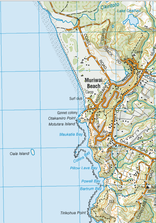
Topographic map of Muriwai
| muriwai_topo_map.png |
Elements of the Coast at Muriwai
SAND DUNES
This is an example of the type of sand dunes you will see at Muriwai. Notice they are quite steep or "cliffed" and are also covered in different types of vegetation. The roots of the plants help to stabilise the dune so that it becomes more resistant to being eroded by both wave and aeolian (wind) processes.
This is an example of the type of sand dunes you will see at Muriwai. Notice they are quite steep or "cliffed" and are also covered in different types of vegetation. The roots of the plants help to stabilise the dune so that it becomes more resistant to being eroded by both wave and aeolian (wind) processes.
Aeolian Erosion is erosion caused by the WIND and is mainly responsible for the formation of sand dunes. There are three types - surface creep, suspension and saltation.
THE SHORE PLATFORM :- Below are photographs of the shore platform although they can also be called "wave cut" platforms although this is a bit misleading as these platforms can be formed by more than just wave processes. Notice the top of the platform has indentations and holes formed into it. This is caused by chemical weathering where salt water H2O and NaCl react with the limestone (Calcium Carbonate) CaCO3 and dissolve it.
2014 as you can see the blowhole is much smaller at this time.
2017
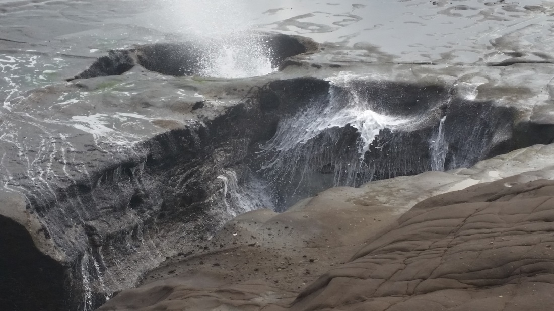
2019 the jointing of softer sandstone that glues the blocks of limestone together has been eroded by hydraulic action widening the mouth of the blowhole.
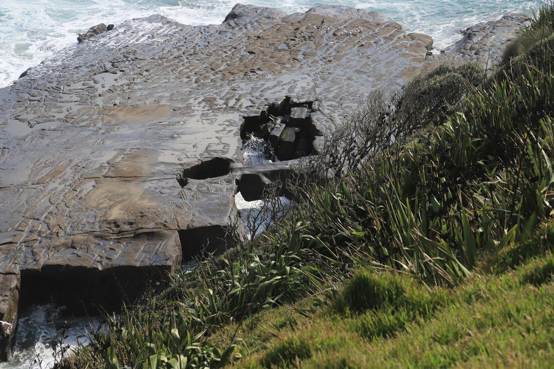
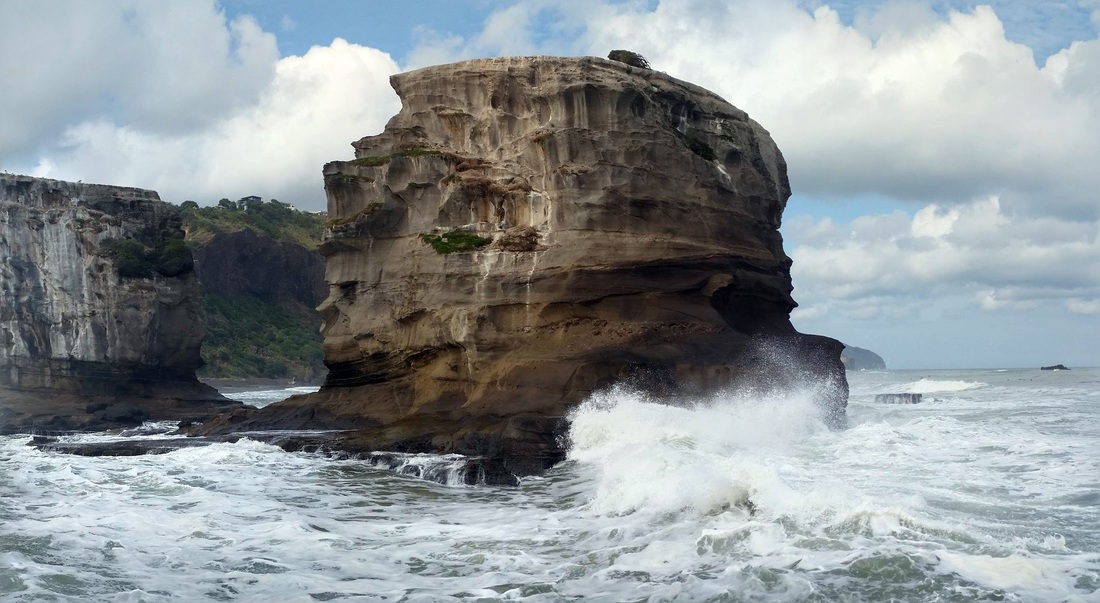
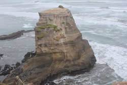
The Stack - Motutara Island
Processes that operate at the Coast
Waves, tides and currents are the physical processes that shape the coast. The force of these processes wears down the coast in some places and builds it up in others, transports sand and shell, shapes spits and coastal bays and makes rivers change their course.
Wave Dynamics
Waves are the driving force behind all changes we see from day to day on the beaches of Auckland. When characterising the wave climate we refer to wave height, length, period and direction.
Wave height: Is the distance from the crest to the trough. We often speak of significant wave height. This is the average wave height of the largest 1/3 of the waves and closely equals visual observations as most people tend to overestimate wave heights.
Wave length: Is the distance from crest to crest.
Wave period (T): Is the time is takes for one wave length to pass a point. Waves that have travelled from a long distance away generally have a longer period than waves formed close by.
Wave direction: Is the direction the wave is propagating (travelling) towards e.g. a strong NE wind will generate SW waves.
Inside a wave
Water particles inside a wave travel in a circular motion, moving forward on the crest and backwards on the trough (depression in the wave), with vertical movement occurring between the two. The net movement of water is with the direction of the wave. We often see objects such as birds, boats and even people floating on the water surface being passed by wave crest after wave crest yet remaining in the same position.
In deep water the orbital motion of a wave is very small. Anyone who has done scuba diving will know that when surface waves are present, conditions are uncomfortable near the surface but the conditions improve with depth as increasingly calmer water is reached.
As waves approach shore and water depths decrease the wave starts to “feel” the bottom and the circular motion of the water particles becomes flatter as the orbits cannot be completed. When this happens the bottom of the wave starts to slow down, and the wave reaches a critical steepness at which point it becomes unstable and breaks. This is why in deep water waves look small, but as they approach the beach they seem to increase in size.
Types of Waves
Sea waves: are generated by wind blowing across the sea surface. Friction at the surface causes water particles to pile up into waves which are then pushed across the water. As soon as the wind has a surface against which to push it transfers more energy to this surface and waves begin to increase in size.
The size of the wave increases with the speed of the wind, its duration and the distance of the open water over which it travels — this distance is called the fetch. When the wind has been blowing hard for many hours and has a long fetch, the waves become large and powerful. Sea waves vary in time and space and there can be many different sized waves moving in different directions in any one location. These sea states can be measured and analysed using electronic sensors such as ARC’s directional wave rider bouy.
Swell waves: When waves move away from where they were formed they become well rounded long waves with similar energy and sizes. Swell waves have the same origin as wind waves, but after travelling a long distance have outrun all of the smaller period waves generated with them there continued movement is due to the force of gravity. Without anything to stop or slow the progress of these gravity waves, they do not peak in deep water and their energy is not lost. Swell waves are the waves that help make great surf and also make your fishing boat rock. As swell waves get closer to the beach they become closer together and the crest of the wave becomes bigger to form surf waves.
Tsunami: A tsunami originates when a forceful earthquake or landslide suddenly shifts or displaces a large amount of seawater and sets a train of waves in motion on the sea surface. As the tsunami approaches the continental coast, it begins to slow and steepen in relatively deep water because of its enormous wavelength.
What happens when waves approach the shore?As we have discussed, waves are transformed when they reach shallower water and start to “feel” bottom friction (like a resisting force) from the seabed. When waves approach obstacles wave energy is either reflected, refracted or diffracted.
Reflection: When waves meet seawalls, jetties and other steep or solid structures the wave energy is reflected (like a mirror) back out to sea. Reflected wave energy is then added to the next incoming wave.
In most natural situations a portion of the wave energy is reflected and the rest is dissipated or absorbed by the surface of the obstacle. The more porous the beach or obstacle the more wave energy is dissipated. For example on a gravel beach more wave energy is absorbed as coarse particles allow water to filter through the large gaps (this is known as percolation).
Refraction: Waves rarely approach the shore parallel to the coastline. As waves approach at an angle, parts of the wave “feel” the seabed before other parts, therefore some parts of the wave slow down before the rest. Slowing takes place at different times along the front of the wave and the result is a bending or refracting of the wave as it passes through shallow water. For example a wave entering an embayment spreads into the shape and wave energy is dissipated (effectively scattered) along the shoreline of the bay and is concentrated at the headland.
Diffraction: When waves pass a steep sided island, spit or end of a breakwater some of the wave energy is spread sideways behind the obstacle. This is why we can observed boats in the shelter of a breakwater still being jostled by passing wave energy.
Destructive Waves are characterized by high frequency, which implies that the swash is impeded by the backwash from the preceding wave. The backwash is more effective than the swash in moving material, and waves having this character are usually steep and associated with onshore winds. This means that the wave breaks heavily on the beach and they arrive at a relatively rapid succession while the backwash of the wave is travelling down the beach the swash of the next wave is travelling up the beach. This reduces the ability of swash to carry sand up the beach and results in more sediment moving seaward. This tends to reduce the gradient of the beach (make it shallower) meaning at high tides or during storms when there is significantly more energy destructive waves can erode beaches and dunes and move sediment into the water where it can be transported by drift processes. These waves usually tend to occur during winter.
Constructive Waves are the waves that build up the beaches. They have a large 'swash', which means they can carry deposits of sand and other materials far up the beach. The beaches generally have a steeper gradient and dunes have more sand deposited on them. These waves usually tend to occur during summer.
Tides
Along all coasts of the world water level rises and falls with a regular rhythm know as the tide. The water level rises on the flood tide until high tide is reached; then the level falls during ebb tide to the low tide level. The force acting on water to produce ocean tides is caused by the gravitational attraction of the sun and moon. When the sun and moon are aligned the two attractions reinforce each other and we get very high spring tides.
Storm surges:
Storms and near storm conditions increase the tidal range beyond the high tide level predicted on tide tables. The rise in water level begins with a local atmospheric low pressure system that lifts the sea surface. High winds that rush into the low pressure area add to the rise. Depending on wind direction and the shape of the coastline, the surge may move toward the shore as a positive storm surge or away from the shore as a negative storm surge. Positive storm surges commonly cause flooding.
Currents
Currents are generated by both wave and tidal energy or occur when warm and cold water mix such as the sub-Antarctic convergence
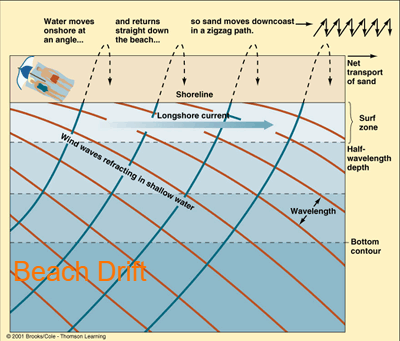
Longshore currents: When waves approach the shoreline at an angle refraction occurs and a longshore current is generated. Sand that is suspended by waves is then transported by the longshore currents. The greatest volumes of sand are transported on open ocean beaches where massive sandbars, spits and other sediment accumulations are evidence of the power of longshore currents.
Rip currents: are formed when the water is piled up against the beach from repetitive breaking waves. The trapped water seeks a path of least resistance to flow back out to sea. As the water that is pushed and piled up against the beach as to go somewhere. This unstable condition is most pronounced when strong onshore winds are blowing. Low spots in the approaching breakers in the surf zone and clouds of suspended sediment moving seaward are the best clues to the presence of a rip current. The rip current is one side of a cell like system circulating water within the breaker zone, and acts like a river flowing swiftly back out to sea. Water moves toward the shore in the incoming waves, after the waves break the water flows down the shore in longshore currents, and then back out again in rip currents.
Tidal currents: Water levels rise on the flood tide (flood tidal current) until high tide is reached; and then fall during ebb tide (ebb tidal current) to the low tide level. There is generally a period of slack water when tidal currents are reversed about an hour around the turning of each tide.
In the open coast the flood and ebb tidal currents are generally masked by wave energy. Tidal currents are generally more noticeable in harbours and estuaries where large volumes of water are forced into and out of a narrow constriction during a tidal cycle.
What is coastal erosion?
Coastal landforms exist because hydrodynamic (waves, currents, tides) and aeolian (wind) processes erode, transport and deposit particles of sediment. Our coastline and beaches are constantly on the move - changes in the position of the coastline are a normal process on virtually every part of the region’s coastline. The change in position or shape of the coastline is almost always the result of both human activities and natural processes.
Short term and long term erosion. For coastal management purposes it is useful to distinguish between short term and long term coastal erosion. Short-term coastal erosion is associated with dynamic coastline changes which occur on all beaches. Averaged over time these fluctuations do not result in permanent coastline retreat. In these situations the coastline affected by such movements is properly regarded as part of the active beach and is commonly referred to as the "dynamic envelope".
Coastal erosion is the long term (20 years or more) landward movement of the coastline.
How is erosion caused?Coastal erosion is often attributed to storm events, and in particular to those storm events when high wave energy, strong on-shore winds and heavy rainfall coincide with a high tide. The real cause of erosion however is often more difficult to determine, and usually requires the skilled interpretation of the processes and activities affecting the site. For instance, changes in the position of the coastline might be associated with a reduction in sediment supply to a beach, the interaction of coastal processes with coastal structures, or the in-appropriate discharge of stormwater.
While coastal erosion is a natural process, i.e. the result of coastal processes and their interaction with land, it may be that the process is initiated and/or exacerbated by human activity. In the Auckland region there are numerous examples where human activities have contributed to or caused coastal erosion, e.g. at Omaha and Mission Bay beaches. Typical causes of beach erosion include: change in sediment supply, wave processes or sea level, over a range of time scales; windborne sediment transport, formation of updrift littoral barriers (e.g. through a rockfall); loss of headland control (e.g. through erosion of that feature), scouring of beach by stormwater discharges; and loss of vegetation.
Wave Dynamics
Waves are the driving force behind all changes we see from day to day on the beaches of Auckland. When characterising the wave climate we refer to wave height, length, period and direction.
Wave height: Is the distance from the crest to the trough. We often speak of significant wave height. This is the average wave height of the largest 1/3 of the waves and closely equals visual observations as most people tend to overestimate wave heights.
Wave length: Is the distance from crest to crest.
Wave period (T): Is the time is takes for one wave length to pass a point. Waves that have travelled from a long distance away generally have a longer period than waves formed close by.
Wave direction: Is the direction the wave is propagating (travelling) towards e.g. a strong NE wind will generate SW waves.
Inside a wave
Water particles inside a wave travel in a circular motion, moving forward on the crest and backwards on the trough (depression in the wave), with vertical movement occurring between the two. The net movement of water is with the direction of the wave. We often see objects such as birds, boats and even people floating on the water surface being passed by wave crest after wave crest yet remaining in the same position.
In deep water the orbital motion of a wave is very small. Anyone who has done scuba diving will know that when surface waves are present, conditions are uncomfortable near the surface but the conditions improve with depth as increasingly calmer water is reached.
As waves approach shore and water depths decrease the wave starts to “feel” the bottom and the circular motion of the water particles becomes flatter as the orbits cannot be completed. When this happens the bottom of the wave starts to slow down, and the wave reaches a critical steepness at which point it becomes unstable and breaks. This is why in deep water waves look small, but as they approach the beach they seem to increase in size.
Types of Waves
Sea waves: are generated by wind blowing across the sea surface. Friction at the surface causes water particles to pile up into waves which are then pushed across the water. As soon as the wind has a surface against which to push it transfers more energy to this surface and waves begin to increase in size.
The size of the wave increases with the speed of the wind, its duration and the distance of the open water over which it travels — this distance is called the fetch. When the wind has been blowing hard for many hours and has a long fetch, the waves become large and powerful. Sea waves vary in time and space and there can be many different sized waves moving in different directions in any one location. These sea states can be measured and analysed using electronic sensors such as ARC’s directional wave rider bouy.
Swell waves: When waves move away from where they were formed they become well rounded long waves with similar energy and sizes. Swell waves have the same origin as wind waves, but after travelling a long distance have outrun all of the smaller period waves generated with them there continued movement is due to the force of gravity. Without anything to stop or slow the progress of these gravity waves, they do not peak in deep water and their energy is not lost. Swell waves are the waves that help make great surf and also make your fishing boat rock. As swell waves get closer to the beach they become closer together and the crest of the wave becomes bigger to form surf waves.
Tsunami: A tsunami originates when a forceful earthquake or landslide suddenly shifts or displaces a large amount of seawater and sets a train of waves in motion on the sea surface. As the tsunami approaches the continental coast, it begins to slow and steepen in relatively deep water because of its enormous wavelength.
What happens when waves approach the shore?As we have discussed, waves are transformed when they reach shallower water and start to “feel” bottom friction (like a resisting force) from the seabed. When waves approach obstacles wave energy is either reflected, refracted or diffracted.
Reflection: When waves meet seawalls, jetties and other steep or solid structures the wave energy is reflected (like a mirror) back out to sea. Reflected wave energy is then added to the next incoming wave.
In most natural situations a portion of the wave energy is reflected and the rest is dissipated or absorbed by the surface of the obstacle. The more porous the beach or obstacle the more wave energy is dissipated. For example on a gravel beach more wave energy is absorbed as coarse particles allow water to filter through the large gaps (this is known as percolation).
Refraction: Waves rarely approach the shore parallel to the coastline. As waves approach at an angle, parts of the wave “feel” the seabed before other parts, therefore some parts of the wave slow down before the rest. Slowing takes place at different times along the front of the wave and the result is a bending or refracting of the wave as it passes through shallow water. For example a wave entering an embayment spreads into the shape and wave energy is dissipated (effectively scattered) along the shoreline of the bay and is concentrated at the headland.
Diffraction: When waves pass a steep sided island, spit or end of a breakwater some of the wave energy is spread sideways behind the obstacle. This is why we can observed boats in the shelter of a breakwater still being jostled by passing wave energy.
Destructive Waves are characterized by high frequency, which implies that the swash is impeded by the backwash from the preceding wave. The backwash is more effective than the swash in moving material, and waves having this character are usually steep and associated with onshore winds. This means that the wave breaks heavily on the beach and they arrive at a relatively rapid succession while the backwash of the wave is travelling down the beach the swash of the next wave is travelling up the beach. This reduces the ability of swash to carry sand up the beach and results in more sediment moving seaward. This tends to reduce the gradient of the beach (make it shallower) meaning at high tides or during storms when there is significantly more energy destructive waves can erode beaches and dunes and move sediment into the water where it can be transported by drift processes. These waves usually tend to occur during winter.
Constructive Waves are the waves that build up the beaches. They have a large 'swash', which means they can carry deposits of sand and other materials far up the beach. The beaches generally have a steeper gradient and dunes have more sand deposited on them. These waves usually tend to occur during summer.
Tides
Along all coasts of the world water level rises and falls with a regular rhythm know as the tide. The water level rises on the flood tide until high tide is reached; then the level falls during ebb tide to the low tide level. The force acting on water to produce ocean tides is caused by the gravitational attraction of the sun and moon. When the sun and moon are aligned the two attractions reinforce each other and we get very high spring tides.
Storm surges:
Storms and near storm conditions increase the tidal range beyond the high tide level predicted on tide tables. The rise in water level begins with a local atmospheric low pressure system that lifts the sea surface. High winds that rush into the low pressure area add to the rise. Depending on wind direction and the shape of the coastline, the surge may move toward the shore as a positive storm surge or away from the shore as a negative storm surge. Positive storm surges commonly cause flooding.
Currents
Currents are generated by both wave and tidal energy or occur when warm and cold water mix such as the sub-Antarctic convergence
Longshore currents: When waves approach the shoreline at an angle refraction occurs and a longshore current is generated. Sand that is suspended by waves is then transported by the longshore currents. The greatest volumes of sand are transported on open ocean beaches where massive sandbars, spits and other sediment accumulations are evidence of the power of longshore currents.
Rip currents: are formed when the water is piled up against the beach from repetitive breaking waves. The trapped water seeks a path of least resistance to flow back out to sea. As the water that is pushed and piled up against the beach as to go somewhere. This unstable condition is most pronounced when strong onshore winds are blowing. Low spots in the approaching breakers in the surf zone and clouds of suspended sediment moving seaward are the best clues to the presence of a rip current. The rip current is one side of a cell like system circulating water within the breaker zone, and acts like a river flowing swiftly back out to sea. Water moves toward the shore in the incoming waves, after the waves break the water flows down the shore in longshore currents, and then back out again in rip currents.
Tidal currents: Water levels rise on the flood tide (flood tidal current) until high tide is reached; and then fall during ebb tide (ebb tidal current) to the low tide level. There is generally a period of slack water when tidal currents are reversed about an hour around the turning of each tide.
In the open coast the flood and ebb tidal currents are generally masked by wave energy. Tidal currents are generally more noticeable in harbours and estuaries where large volumes of water are forced into and out of a narrow constriction during a tidal cycle.
What is coastal erosion?
Coastal landforms exist because hydrodynamic (waves, currents, tides) and aeolian (wind) processes erode, transport and deposit particles of sediment. Our coastline and beaches are constantly on the move - changes in the position of the coastline are a normal process on virtually every part of the region’s coastline. The change in position or shape of the coastline is almost always the result of both human activities and natural processes.
Short term and long term erosion. For coastal management purposes it is useful to distinguish between short term and long term coastal erosion. Short-term coastal erosion is associated with dynamic coastline changes which occur on all beaches. Averaged over time these fluctuations do not result in permanent coastline retreat. In these situations the coastline affected by such movements is properly regarded as part of the active beach and is commonly referred to as the "dynamic envelope".
Coastal erosion is the long term (20 years or more) landward movement of the coastline.
How is erosion caused?Coastal erosion is often attributed to storm events, and in particular to those storm events when high wave energy, strong on-shore winds and heavy rainfall coincide with a high tide. The real cause of erosion however is often more difficult to determine, and usually requires the skilled interpretation of the processes and activities affecting the site. For instance, changes in the position of the coastline might be associated with a reduction in sediment supply to a beach, the interaction of coastal processes with coastal structures, or the in-appropriate discharge of stormwater.
While coastal erosion is a natural process, i.e. the result of coastal processes and their interaction with land, it may be that the process is initiated and/or exacerbated by human activity. In the Auckland region there are numerous examples where human activities have contributed to or caused coastal erosion, e.g. at Omaha and Mission Bay beaches. Typical causes of beach erosion include: change in sediment supply, wave processes or sea level, over a range of time scales; windborne sediment transport, formation of updrift littoral barriers (e.g. through a rockfall); loss of headland control (e.g. through erosion of that feature), scouring of beach by stormwater discharges; and loss of vegetation.
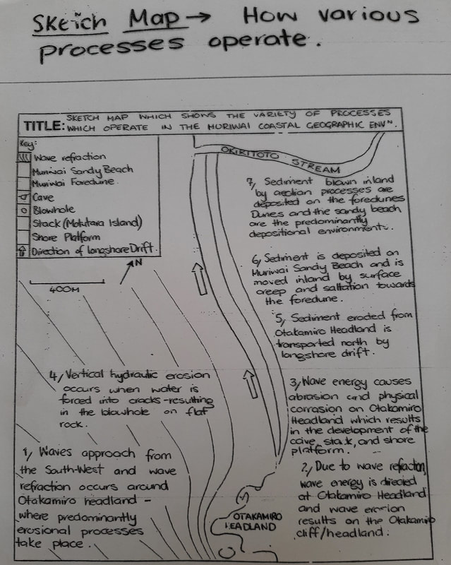
HOW DO THE PROCESSES OPERATE AT MURIWAI?
So in this section I hope to be able to give you an idea of what is expected in the exam for the Level 3 Natural Process question.
I'm going to assume that you understand the terminology used such as wave refraction or hydraulic action or saltation etc. If not then download the glossary and look them up. If you have any questions message me - see Contact details
Let's break the Environment at Muriwai up into three areas. The cliffs and shore platform to the south, the beach and dunes in the middle and the river and delta to the north.
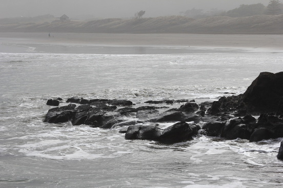
CLIFF AND SHORE PLATFORM
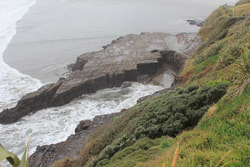
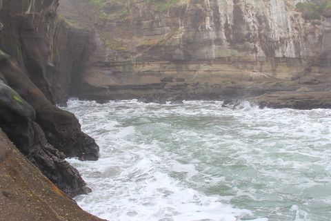
This area in the south of the study area consists of cliffs made up of pillow lava around Maori Bay then sandstone mixed with volcanic rock such as scoria called Manukau Breccia further north.
A large stack called Motutara Island lies next to the shore platform while a long gut has been formed in the middle of the platform ending in a blowhole that has been enlarged recently by continuous hydraulic action of waves. A cave has been formed as waves refract around the platform and hydraulic action has attacked a weak fissure in the rock of the cliff.
CAN YOU DRAW A MAP OF THIS AREA SHOWING WHERE THE FEATURES ARE AND HOW THE PROCESSES OPERATE TO FORM AND SHAPE EACH FEATURE?
BEACH AND DUNES
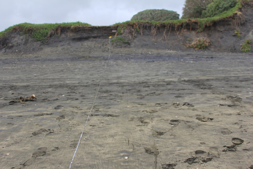
The beach and dune area at Muriwai stretch for approximately two kilometres from the shore platform to Okiritoto Stream. The beach is characterised by a wide tidal area that extends to an offshore bar to the west and the dunes to the east of the beach. Beach drift and longshore currents tend to move sediment in a northerly direction meaning dunes to the south tend to erode easily through a combination of wave action, littoral drift and aeolian erosion. The sand dunes at Muriwai tend to be cliffed (i.e. the front or seaward side of them are steep). due to being eroded by wave action while the back of the dunes have a shallower profile.
RIVER AND DELTA
Okiritoto Stream runs from the Woodhill area west to the sea. It forms a delta at the mouth of the river approximately 60 metres across.
So in this section I hope to be able to give you an idea of what is expected in the exam for the Level 3 Natural Process question.
I'm going to assume that you understand the terminology used such as wave refraction or hydraulic action or saltation etc. If not then download the glossary and look them up. If you have any questions message me - see Contact details
Let's break the Environment at Muriwai up into three areas. The cliffs and shore platform to the south, the beach and dunes in the middle and the river and delta to the north.
CLIFF AND SHORE PLATFORM
This area in the south of the study area consists of cliffs made up of pillow lava around Maori Bay then sandstone mixed with volcanic rock such as scoria called Manukau Breccia further north.
A large stack called Motutara Island lies next to the shore platform while a long gut has been formed in the middle of the platform ending in a blowhole that has been enlarged recently by continuous hydraulic action of waves. A cave has been formed as waves refract around the platform and hydraulic action has attacked a weak fissure in the rock of the cliff.
CAN YOU DRAW A MAP OF THIS AREA SHOWING WHERE THE FEATURES ARE AND HOW THE PROCESSES OPERATE TO FORM AND SHAPE EACH FEATURE?
BEACH AND DUNES
The beach and dune area at Muriwai stretch for approximately two kilometres from the shore platform to Okiritoto Stream. The beach is characterised by a wide tidal area that extends to an offshore bar to the west and the dunes to the east of the beach. Beach drift and longshore currents tend to move sediment in a northerly direction meaning dunes to the south tend to erode easily through a combination of wave action, littoral drift and aeolian erosion. The sand dunes at Muriwai tend to be cliffed (i.e. the front or seaward side of them are steep). due to being eroded by wave action while the back of the dunes have a shallower profile.
RIVER AND DELTA
Okiritoto Stream runs from the Woodhill area west to the sea. It forms a delta at the mouth of the river approximately 60 metres across.
Spatial Variations
| spatialvariation_at_muriwai.ppt |
Some advanced information for Excellence
| muriwaichmsb.pdf |
| study_version_demonstrate_understanding_of_how_interacting_natural_processes_shape_a_new_zealand_geographic_environment_3.1.pdf |
Information gathered by the 2014 students
| muriwai_coastal_geographic_environment_fieldtrip_18_august_2014.docx |
| glossary_of_maori_terms.docx |
A link to a good site on Erosion processes at the Coast
Some good Youtube resources

